
Florida Weather Alert: New Radar Goes Live as Storm Chances Rise Across the U.S.
Florida Weather Alert: New Radar Goes Live as Storm Chances Rise Across the U.S. A new weather radar installation in Lee County, Florida, is now complete as forecasters monitor an active pattern bringing repeated shower and thunderstorm chances across parts of the United States. The new radar is designed to improve severe-weather monitoring in an...
Linda
Aug 11, 2026 · 3 min Read
Key Highlights
- Lee County's first weather radar installation is complete, according to the Sanibel-Captiva Islander.
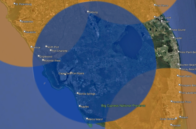
- The radar project is intended to address a known gap in weather-radar coverage across the region.
- Lee County previously announced a public-private partnership with Climavision to install radar equipment on the roof of the Lee County Public Safety Center.
- Local forecasts are also highlighting humidity, haze and recurring shower and thunderstorm chances.
- Lee, Florida, can experience substantial heat during August, with monthly forecast highs reaching into the 90s.
- Florida's subtropical climate makes detailed, high-frequency weather observations particularly valuable for monitoring rapidly changing conditions.
Florida Weather Alert: New Radar Goes Live as Storm Chances Rise Across the U.S.
A new weather radar installation in Lee County, Florida, is now complete as forecasters monitor an active pattern bringing repeated shower and thunderstorm chances across parts of the United States. The new radar is designed to improve severe-weather monitoring in an area where radar coverage has historically had gaps.
Weather is becoming a bigger story across several U.S. regions this week, with storm chances, high humidity and improved weather-monitoring technology all drawing attention.
In Lee County, Florida, a new weather radar installation has reached a major milestone. The project was designed to improve radar coverage and give emergency officials and forecasters better information when severe weather develops.
At the same time, weather forecasts elsewhere are pointing toward a humid and unsettled pattern, with showers and thunderstorms expected to remain possible through parts of the week.
The combination matters because better radar data can give communities more information about the location and movement of developing storms.
🌦️ Why the New Lee County Radar Matters
Weather radar is more than a tool for showing where it is raining.
Radar allows meteorologists to track the location, intensity and movement of precipitation and identify developing storm structures.
That becomes particularly important in areas where conventional radar coverage leaves gaps.
Lee County Government announced in September 2025 that it had entered a public-private partnership intended to improve radar coverage and severe-weather monitoring in the county. The equipment was planned for the roof of the Lee County Public Safety Center.
The goal was straightforward: provide more localized weather information and improve access to data that can support forecasting.
With the installation now reported as complete, the project moves from construction into its operational phase.
📡 What the Radar Can Actually Help Detect
A localized radar system can provide valuable information about storms as they develop.
Among the most important uses are:
Rainfall intensity
Radar can help meteorologists determine where precipitation is becoming heavier.
Storm movement
Tracking the direction and speed of storm cells can help officials understand which communities may be affected next.
Severe-weather development
Radar observations can provide important clues about thunderstorms that may become more organized or intense.
Emergency management
More localized information can help emergency officials make better-informed decisions during threatening weather.
Short-term forecasting
The closer the observations are to the affected area, the more useful they can be for understanding rapidly changing conditions.
That doesn’t mean a radar installation can prevent severe weather.
It means communities can have better information about what the weather is doing.
⛈️ Storm Chances Are Increasing in Other Parts of the U.S.
The radar announcement comes as several regions are dealing with unsettled weather.
Forecast coverage from WOODTV highlighted humid and hazy conditions with storm chances, while KEYC reported an active week featuring on-and-off showers and thunderstorms.
That type of weather pattern can create difficult forecasting conditions because storms may develop repeatedly rather than arriving as one clearly defined weather system.
For residents, that means a dry morning does not necessarily guarantee a dry afternoon.
Weather can change quickly, particularly during summer.
🌡️ Why Humidity Makes the Weather Feel Worse
Humidity is an important part of the story.
When the atmosphere contains more moisture, temperatures can feel significantly hotter because the body has a harder time cooling itself through evaporation.
Lee, Florida’s August forecast illustrates the heat component: AccuWeather’s 2026 monthly outlook shows temperatures frequently reaching the upper 80s and 90s Fahrenheit.
Add moisture and storm development to that environment, and residents can experience:
- muggy conditions;
- sudden heavy rain;
- lightning;
- gusty winds;
- localized flooding;
- and rapid changes in visibility.
⚡ The Biggest Risk Isn’t Always the Rain
Thunderstorms can produce several hazards simultaneously.
Heavy rainfall can overwhelm drainage systems, while lightning can pose a serious danger to people outdoors.
Strong winds can also damage trees, power lines and structures.
That’s why weather radar is particularly valuable.
The objective isn’t simply to know whether rain is coming.
Forecasters need to know:
Where is the storm?
How fast is it moving?
Is it strengthening?
Which populated areas could be affected?
A stronger local observation network can help answer those questions faster.
🌀 Why Florida Needs Strong Weather Monitoring
Florida’s geography and climate create a complicated forecasting environment.
The state regularly experiences rapidly developing thunderstorms, particularly during warm and humid periods.
Research using Florida’s Automated Weather Network has highlighted the importance of high-temporal-resolution weather observations in the state’s subtropical environment, including for understanding extreme weather and other climate-related impacts.
That makes additional observation infrastructure potentially valuable to forecasters, emergency managers and local authorities.
🏠 What Residents Should Do During Stormy Weather
A radar installation doesn’t replace personal preparedness.
When thunderstorms are forecast:
1. Check the forecast before leaving home
Conditions can change quickly.
2. Keep your phone charged
Severe-weather warnings can arrive while you’re away from home.
3. Take lightning seriously
If thunder is audible, lightning is close enough to pose a danger.
4. Avoid flooded roads
Even shallow-looking water can hide dangerous road conditions.
5. Secure outdoor objects
Loose furniture, decorations and other objects can become dangerous during strong winds.
6. Follow official warnings
If authorities issue an evacuation or shelter instruction, follow it rather than relying solely on social media posts.
🔮 Weather Outlook: What to Watch Next
The immediate weather story is likely to remain focused on storm timing rather than one single nationwide weather event.
For areas seeing repeated shower and thunderstorm chances, residents should watch for changes in:
- storm coverage;
- rainfall intensity;
- lightning frequency;
- wind gusts;
- localized flooding;
- and severe-weather alerts.
In Lee County, the completion of the radar installation provides another piece of infrastructure for monitoring those conditions.
The more important test now is how the new radar performs operationally and how its data is incorporated into local forecasting and emergency management.
📊 Why Better Radar Could Improve Severe-Weather Response
The biggest benefit may come when radar information is combined with other weather observations.
Think of the system as part of a larger chain:
Weather observations → Radar → Meteorologists → Emergency managers → Public alerts
Radar alone cannot predict every storm perfectly.
But better observations can help reduce uncertainty.
That’s particularly important when thunderstorms form quickly and conditions change within minutes.
🟢 The Bigger Picture
The Lee County radar project is significant because weather forecasting is increasingly dependent on high-resolution, localized data.
National radar networks remain essential, but local gaps can make it harder to see exactly what is happening close to the ground.
The new installation was specifically designed to address that problem.
Lee County Government previously said the project would help fill a known gap in National Weather Service radar coverage and improve monitoring and forecasting of severe weather.
Now that the installation has been completed, the focus shifts toward how effectively the new information can support real-time forecasting.
🏆 Bottom Line
The completion of Lee County’s new weather radar comes at a time when storm chances remain elevated across parts of the country.
For Florida residents, the radar represents more than another piece of weather technology. It is intended to improve the amount of localized information available when storms develop.
Meanwhile, forecasts pointing toward humidity, haze and recurring thunderstorms mean residents should remain alert to changing conditions rather than relying on a single daily forecast.
The key message is simple:
Better radar doesn’t stop storms—but it can help communities see them coming more clearly.
❓ FAQs
What happened with the new Lee County weather radar?
A new weather radar installation in Lee County, Florida, has been reported as complete. The project was designed to improve local weather-radar coverage and severe-weather monitoring.
Why does Lee County need another weather radar?
Lee County Government previously identified a gap in radar coverage and said the new system would improve access to weather data and severe-weather forecasting.
Who was involved in the Lee County radar project?
Lee County entered a public-private partnership with Kentucky-based Climavision for the radar installation, according to the county’s announcement.
Can the new radar predict hurricanes?
Radar can provide valuable information about precipitation and storm structure, but it does not independently predict hurricanes. Forecasters use radar alongside satellites, models, surface observations and other data.
Are thunderstorms expected this week?
Several regional forecasts are calling for periods of showers and thunderstorms, although the exact timing and intensity varies by location.
Why is humidity important during storms?
High humidity contributes to uncomfortable heat and provides moisture that can support thunderstorm development.
Is the new radar only useful during severe weather?
No. Radar can also be useful for monitoring ordinary rainfall, storm movement and precipitation intensity.
What should residents do during thunderstorms?
Stay informed through official weather alerts, avoid exposed areas during lightning, and take precautions against heavy rain, strong winds and flooding.
🪙 Gold Price Today — Live Market Check
Weather and markets may seem unrelated, but gold remains highly sensitive to inflation expectations, interest-rate expectations and geopolitical risk.
Gold was trading near a more than two-month high on August 11, with Reuters reporting spot gold around $4,393.69 per ounce after reaching an intraday high of $4,434.84. The market was also watching upcoming U.S. inflation data for clues about Federal Reserve policy.
For the latest live domestic rates, readers can check:
GoldPriceNow.in — Live Gold Price
Note: I could not independently retrieve GoldPriceNow.in’s live quote in this check, so I have not inserted an unverified rupee price.
🌐 Key Resources
Keep reading
Related Articles
 Commodities
Oil Nears $95: Could the Iran War Trigger a New U.S. Inflation Shock?
Oil at $95 Is Not the Real Story A crude-oil headline is easy to write: “Oil prices rise as Iran tensions escalate.” Reuters, Bloomberg, CNBC and WSJ can publish that story within minutes. But for TheBusinessNow, that isn’t enough. The bigger question is: What happens to the American economy if oil stays near $95 —...
 Economy
U.S. National Debt Hits $40 Trillion: Why Treasury Yields Are Rising Again
The $40 Trillion Number Is Not the Whole Story The United States has crossed a psychological and financial milestone. $40 trillion. But simply writing “America owes $40 trillion” misses the more important story. The real question for markets is: Who is willing to finance America’s growing debt — and at what interest rate? That question...
 Commodities
Strait of Hormuz Standoff: The Oil Shock That Could Hit the U.S. Economy Next
Strait of Hormuz Standoff: Why the Oil Market Is Getting Nervous Again The oil market is being forced to price a problem that seemed to be easing only weeks ago: the Strait of Hormuz is still not reliably functioning as a normal commercial shipping route. On August 19, Brent crude was trading around $91.20 a...
Comments (0)