
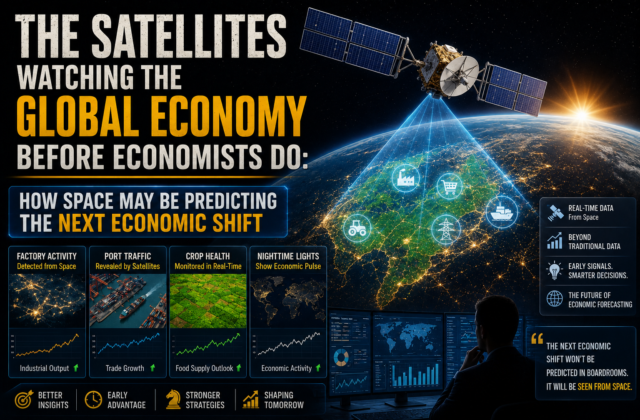
The Satellites Watching the Global Economy Before Economists Do: How Space May Be Predicting the Next Economic Shift
he Satellites Watching the Global Economy Before Economists Do: The Hidden Data Powering Modern Markets Imagine knowing that economic activity is slowing weeks before governments publish official data. Imagine detecting supply chain disruptions before shipping companies issue warnings. Imagine seeing whether factories are running at full capacity, whether ports are congested, or whether crops are...
TheBusinessNow
Jul 21, 2026 · 3 min Read
Key Highlights
- 🛰️ Commercial satellites are providing near real-time observations of ports, factories, farms, and energy infrastructure.
- 📊 Investors increasingly combine satellite imagery with traditional economic indicators to gain additional insight into global economic activity.
- 🚢 Port congestion visible from space can help businesses monitor supply chain trends before some official trade data is released.
- 🌾 Satellite monitoring of crops, droughts, and floods supports agricultural forecasting and commodity market analysis.
- ⚡ AI-powered image analysis enables faster interpretation of massive volumes of Earth-observation data.
- 💰 Governments, insurers, logistics companies, researchers, and investment firms all use geospatial intelligence for decision-making.
- 🌍 The future of economic analysis is increasingly blending official statistics with satellite data, artificial intelligence, and advanced analytics.
he Satellites Watching the Global Economy Before Economists Do: The Hidden Data Powering Modern Markets
Imagine knowing that economic activity is slowing weeks before governments publish official data.
Imagine detecting supply chain disruptions before shipping companies issue warnings.
Imagine seeing whether factories are running at full capacity, whether ports are congested, or whether crops are failing—not through reports, but from space.
This isn’t science fiction.
Today, commercial satellites orbiting hundreds of kilometers above Earth are collecting enormous amounts of data every day. Combined with artificial intelligence, cloud computing, and geospatial analytics, that information is helping businesses, investors, insurers, governments, and researchers understand economic activity in near real time.
Traditional economic indicators such as GDP, inflation, and employment remain essential. But they are typically published weeks—or even months—after the underlying activity has already occurred.
Satellite imagery offers something different: a near-live view of the physical economy.
The Economy Leaves Visible Clues
Every economic activity creates physical signals.
Factories consume electricity.
Ports fill with containers.
Parking lots become busier.
Construction sites expand.
Reservoirs rise or shrink.
Crop fields change color.
Ships move through major trade routes.
Modern satellites can observe many of these changes repeatedly over time. When combined with historical data, analysts can identify patterns that may point to accelerating or slowing economic activity.
How Satellites Read the Global Economy
1. Ports Reveal the Pulse of Global Trade
Before official trade statistics are released, satellites can show:
- Container congestion.
- Vessel traffic.
- Storage yard utilization.
- Expansion of logistics facilities.
If major ports suddenly become crowded or unusually quiet, analysts may infer changes in trade flows.
During periods of supply chain disruption, satellite observations have helped researchers and businesses monitor bottlenecks more quickly than some traditional datasets.
2. Factory Activity
Industrial facilities often reveal operational patterns through:
- Vehicle movements.
- Construction activity.
- Changes around warehouses.
- Expansion projects.
While satellites cannot directly measure production output, they can provide visual indicators that complement traditional economic analysis.
3. Agriculture From Orbit
Agriculture remains one of the largest sectors monitored by Earth-observation satellites.
Satellites help estimate:
- Crop health.
- Soil moisture.
- Drought conditions.
- Flood damage.
- Harvest timing.
These insights can influence expectations for food production and commodity markets.
4. Energy Infrastructure
Economic growth often affects energy demand.
Satellites are used to monitor:
- Solar farms.
- Hydroelectric reservoirs.
- Oil storage facilities.
- Gas infrastructure.
- Mining operations.
Combined with other datasets, these observations help analysts understand shifts in industrial activity.
Why Investors Care
Large investment firms increasingly incorporate alternative data into their research.
Satellite imagery is one example of alternative data that can supplement:
- Corporate disclosures.
- Economic reports.
- Industry surveys.
Rather than replacing traditional analysis, satellite observations provide additional context.
Artificial Intelligence Makes the Difference
Modern satellites generate vast quantities of imagery.
Artificial intelligence helps process this information by identifying:
- Ships.
- Buildings.
- Roads.
- Crops.
- Construction activity.
- Environmental changes.
Without AI, analyzing millions of images would be impractical.
Case Study: Shipping
Imagine a major shipping route becomes congested.
Satellite observations may detect:
- Longer vessel queues.
- Reduced movement.
- Increased waiting times.
Businesses may use this information to anticipate supply chain challenges before official reports fully reflect the disruption.
Beyond Finance
Satellite-based economic monitoring also supports:
| Sector | Potential Use |
|---|---|
| Agriculture | Crop monitoring |
| Insurance | Disaster assessment |
| Energy | Infrastructure observation |
| Logistics | Port activity |
| Governments | Environmental monitoring |
| Disaster Response | Floods, fires, storms |
Limitations
Satellite imagery is powerful, but it is not a crystal ball.
Important limitations include:
- Cloud cover affecting visibility.
- Interpretation challenges.
- Data costs.
- Need for complementary information.
- Risk of drawing incorrect conclusions from incomplete observations.
Economic forecasting still requires multiple sources of evidence.
The Future of Economic Intelligence
Several trends are making satellite data more accessible:
- Lower launch costs.
- More commercial Earth-observation satellites.
- Advances in AI.
- Faster cloud computing.
- Improved geospatial analytics.
These developments are expanding the range of organizations that can use satellite-derived insights.
Could Satellites Replace Economists?
Probably not.
Economists analyze consumer behavior, monetary policy, labor markets, inflation, productivity, demographics, and many other factors that satellites cannot directly observe.
However, satellite imagery is becoming an increasingly valuable complement to traditional economic analysis by providing timely information about real-world activity.
Final Analysis
The global economy no longer needs to wait for every official report before meaningful signals begin to emerge.
Every day, satellites capture images of ports, farms, factories, highways, power plants, and infrastructure that reflect how goods, people, and resources move around the world.
When interpreted carefully and combined with conventional data, these observations can help decision-makers respond more quickly to changing conditions.
The future of economic analysis is unlikely to rely on a single source of information. Instead, it will increasingly combine official statistics, market data, artificial intelligence, and observations from space.
The next major economic trend may not first appear in a government report—it may first become visible from orbit.
📊 Quick Facts
| Metric | Insight |
|---|---|
| Earth-observation satellites in orbit | Thousands, operated by governments and commercial companies |
| Typical revisit time | From multiple times per day to several days, depending on the satellite system |
| Key monitored assets | Ports, farms, infrastructure, energy facilities, forests, water bodies |
| Main users | Governments, researchers, insurers, logistics firms, investors |
❓FAQs
How do satellites help monitor the economy?
They provide imagery that can reveal changes in infrastructure, agriculture, shipping, and other physical indicators of economic activity.
Can satellites predict recessions?
No. Satellite data alone cannot predict recessions, but it can contribute useful information when combined with broader economic analysis.
Who uses satellite economic data?
Governments, logistics companies, agricultural organizations, insurers, researchers, and some investment firms.
Is satellite data replacing official statistics?
No. It is generally used as a complementary source of information rather than a replacement.
Why is satellite data becoming more important?
More satellites, improved AI, and lower costs have made geospatial data more timely and accessible than in the past.
Keep reading
Related Articles
 Crypto
₿ Bitcoin Breaks Above $72,000: Why Trump’s Crypto Push Is Sending Crypto Stocks Higher
Bitcoin’s $72,000 Move Is Bigger Than Bitcoin A typical crypto headline would be: Bitcoin jumps above $72,000. But that misses the most important part of today’s move. The interesting part is the simultaneous rally in: Bitcoin ↓ Coinbase ↓ Strategy ↓ Circle ↓ Robinhood ↓ Bitcoin miners ↓ Crypto infrastructure That tells us investors aren’t...
 Markets
U.S. Treasury Doubles Bond Buybacks: Why Markets Are Still Worried About Rising Yields
The Treasury Just Sent Two Messages to Wall Street At first glance, this looks like a straightforward market-support operation. Treasury says: We want to improve liquidity in longer-dated Treasury securities. Investors hear: Washington is increasingly concerned about the rise in long-term borrowing costs. And that second interpretation is what makes this story important. The Treasury...
 Finance
Walmart Stock Plunges 6%: What Its Weak Outlook Says About the U.S. Consumer
Walmart Stock Plunges 6% — But the Earnings Were Not Actually Bad This is where the headline can be misleading. Walmart did not report a disastrous quarter. Quite the opposite. Revenue rose 5.9%, operating income increased 28.8%, e-commerce remained extremely strong and Walmart raised its full-year sales and profit expectations. Yet investors immediately sold the...
Comments (0)